Saint Lucia is an island nation in the Caribbean Sea, located between Martinique and St. Vincent and the Grenadines. It has a population of 160,000 (2016 estimate), with the majority of people residing on the island of Saint Lucia.
The island nation of Saint Lucia is part of the Commonwealth of Nations and a member of the British-speaking community. It is located in the eastern Caribbean Sea, southeast of Martinique, north-northwest of St. Vincent and the Grenadines, and west-southwest of Barbados.
The capital city is Castries. The official language is English and French, with a local dialect.
The currency is the East Caribbean dollar (EC$).
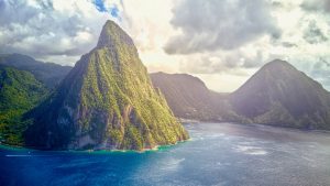
Famed for its spectacular volcanic mountain peaks, white powdery sand beaches and tropical rainforests, Saint Lucia is one of the most beautiful islands in the world. The island’s popularity as a tourist destination has grown in recent years due to its reputation as an eco-friendly destination and its friendly people who are always willing to help visitors find their way around.
Saint Lucia Postal Codes
Anse la Raye
Anse la Raye is a town in north-western Dominica in the Saint George Parish. It is located on the western coast of the island, close to Canefield Airport and La Plaine. The town has a population of 3,200 people and is popular with tourists.
Anse la Raye has a warm tropical climate with little seasonal variation in temperature. The average temperature ranges from 23 °C (73 °F) in July to 28 °C (82 °F) in February, with an annual average of 26.5 °C (80.5 °F).
There are three main beaches at Anse la Raye: Anse Quarry Beach, which has white sand; Anse Toc Versailles Beach, which has black sand; and Anse Miremont Beach which is rocky. The area around the town features many scenic views of mountains and valleys as well as plenty of rainforests and rivers for kayaking or hiking trips.
| Locality | Elevation | Postal Code | Map |
|---|---|---|---|
| Anse la Raye village | 13 m | LC08 101 | View map |
| Au Tabor | 86 m | LC08 105 | View map |
| Au Tabor Hill | 134 m | LC08 105 | View map |
| Caico | 61 m | LC08 402 | View map |
| Invorgoil Estate | 15 m | LC08 104 | View map |
| Jacmel | 96 m | LC08 301 | View map |
| Massacre | 109 m | LC08 102 | View map |
| Millet | 122 m | LC08 401 | View map |
| Morne Ciseaux | 124 m | LC08 302 | View map |
| Morne d’Or | 43 m | LC08 502 | View map |
| Roseau Valley | 7 m | LC08 303 | View map |
| Tet Chemin | 290 m | LC08 404 | View map |
| Vanard | 25 m | LC08 501 | View map |
| Venus | 317 m | LC08 403 | View map |
Canaries
| Locality | Elevation | Postal Code | Map |
|---|---|---|---|
| Anse Galet | 60 m | LC08 103 | View map |
| Anse La Verdue | 266 m | LC08 202 | View map |
| Belvedere | 226 m | LC08 203 | View map |
| Canaries village | 71 m | LC08 201 | View map |
Castries
| Locality | Elevation | Postal Code | Map |
|---|---|---|---|
| Agard Lands | 155 m | LC03 101 | View map |
| Babonneau | 175 m | LC02 101 | View map |
| Bagatelle | 86 m | LC05 207 | View map |
| Balata | 53 m | LC02 201 | View map |
| Barnard Hill | 21 m | LC04 205 | View map |
| Barre St Joseph | 184 m | LC07 105 | View map |
| Belair | 47 m | LC07 204 | View map |
| Bexon | 60 m | LC06 201 | View map |
| Bisee | 37 m | LC02 502 | View map |
| Bishop’s Gap | 54 m | LC05 204 | View map |
| Bocage | 159 m | LC05 101 | View map |
| Bois Patat | 65 m | LC04 102 | View map |
| Cabiche | 137 m | LC02 202 | View map |
| Cacoa Girard | 124 m | LC05 104 | View map |
| Carellie | 113 m | LC03 204 | View map |
| Castries City | 9 m | LC04 302 | View map |
| Cedars | 52 m | LC04 115 | View map |
| Chabotsunbilt | LC04 114 | View map | |
| Chase Gardens | 134 m | LC03 205 | View map |
| Chassin | 111 m | LC02 402 | View map |
| Chaussee Road | LC04 101 | View map | |
| Choc | 10 m | LC02 503 | View map |
| Ciceron | 68 m | LC06 104 | View map |
| City Gate | 64 m | LC03 202 | View map |
| Conway | 12 m | LC04 201 | View map |
| Coubaril | 111 m | LC06 105 | View map |
Choiseul
| Locality | Elevation | Postal Code | Map |
|---|---|---|---|
| Belle Vue | 334 m | LC10 104 | View map |
| Caffiere | 155 m | LC10 106 | View map |
| Cedar Heights | 48 m | LC12 104 | View map |
| Choiseul village | 11 m | LC10 101 | View map |
| Dacretin | 174 m | LC10 108 | View map |
| Debreuil | 196 m | LC10 201 | View map |
| Delcer | 228 m | LC10 102 | View map |
| Derriere Morne | 277 m | LC12 111 | View map |
| Dugard | 303 m | LC10 107 | View map |
| Fiette | 65 m | LC10 111 | View map |
| Gia Bois | 219 m | LC10 306 | View map |
| Industry | 98 m | LC10 118 | View map |
| La Pointe | 74 m | LC10 119 | View map |
| Lamaze | 325 m | LC10 204 | View map |
| Le Riche | 66 m | LC10 116 | View map |
| Martin | 130 m | LC10 117 | View map |
| Mon Tete | 414 m | LC10 202 | View map |
| Monzie | 299 m | LC10 307 | View map |
| Morne Jacques | 400 m | LC10 114 | View map |
| Morne Sion | 120 m | LC10 115 | View map |
| Ponyon | 256 m | LC10 112 | View map |
| Ravineau | 293 m | LC10 109 | View map |
| Reunion | 70 m | LC10 113 | View map |
| River Doree | 49 m | LC10 203 | View map |
| Robleau | 318 m | LC10 205 | View map |
| Savannes George/Constitution Park | 28 m | LC10 308 | View map |
Dennery
| Locality | Elevation | Postal Code | Map |
|---|---|---|---|
| Anse Cannot | 11 m | LC16 105 | View map |
| Aux Lyons | LC17 201 | View map | |
| Belmont | 130 m | LC17 103 | View map |
| Bois Joli | 110 m | LC16 106 | View map |
| Delaide | 50 m | LC17 407 | View map |
| Dennery | 6 m | LC16 101 | View map |
| Derniere Riviere | 41 m | LC17 101 | View map |
| Despinoze | 107 m | LC17 202 | View map |
| Errard | 112 m | LC16 102 | View map |
| Gadette | 189 m | LC17 301 | View map |
| Grande Ravine | 89 m | LC17 406 | View map |
| La Caye | 19 m | LC17 404 | View map |
| La Pointe | 65 m | LC16 104 | View map |
| La Ressource | 17 m | LC17 302 | View map |
| Mabouya Valley | LC17 401 | View map | |
| Morne Panache | 132 m | LC17 405 | View map |
| Over The Bridge | LC16 103 | View map | |
| Riche Fond | 34 m | LC17 403 | View map |
| Thamazo | 113 m | LC17 402 | View map |
| Ti Gadette | LC17 303 | View map | |
| Ti La Ressource | LC17 304 | View map |
Gros Islet
| Locality | Elevation | Postal Code | Map |
|---|---|---|---|
| Americ | 302 m | LC02 106 | View map |
| Baywalk | LC01 601 | View map | |
| Boguis | 32 m | LC02 301 | View map |
| Bois d’Orange | 6 m | LC01 503 | View map |
| Bois d’Orange/Trouya | 39 m | LC01 404 | View map |
| Bonneterre | 42 m | LC01 402 | View map |
| Bonneterre Gardens | 55 m | LC01 105 | View map |
| Cap Estate | 24 m | LC01 104 | View map |
| Cas En Bas | 37 m | LC01 106 | View map |
| Caye Manger | 17 m | LC01 305 | View map |
| Choc Bridge | LC01 504 | View map | |
| Corinth | 24 m | LC01 505 | View map |
| Des Barras | 171 m | LC02 102 | View map |
| Desrameaux | 133 m | LC02 104 | View map |
| East Winds | 30 m | LC01 507 | View map |
| Garrand | 150 m | LC02 103 | View map |
| Grande Riviere | 70 m | LC01 201 | View map |
| Gros Islet Town | 8 m | LC01 101 | View map |
| La Brellotte | 154 m | LC01 506 | View map |
| La Guerre | 166 m | LC02 107 | View map |
| Lafeuille | 45 m | LC01 303 | View map |
| Marisule | 45 m | LC01 501 | View map |
| Marquis Estate | 13 m | LC02 302 | View map |
| Massade | 7 m | LC01 103 | View map |
| Monchy | 124 m | LC01 301 | View map |
| Mongiraud | 32 m | LC01 502 | View map |
Laborie
| Locality | Elevation | Postal Code | Map |
|---|---|---|---|
| Balenbouche | 53 m | LC10 105 | View map |
| Banse La Grace | 201 m | LC11 102 | View map |
| Beausoleil | LC10 305 | View map | |
| Daban | 295 m | LC10 302 | View map |
| Fond Berange | 162 m | LC11 105 | View map |
| Jetrine | LC10 303 | View map | |
| La Haut | 230 m | LC11 104 | View map |
| Laborie | 6 m | LC11 101 | View map |
| Mon Repos Hill | LC11 103 | View map | |
| Piaye | 33 m | LC11 106 | View map |
| Saltibus | 303 m | LC10 301 | View map |
| Tete Morne | 49 m | LC10 304 | View map |
Micoud
| Locality | Elevation | Postal Code | Map |
|---|---|---|---|
| Anse Ger | 64 m | LC14 204 | View map |
| Beauchamp | 32 m | LC14 102 | View map |
| Canelles | 18 m | LC12 206 | View map |
| Chique | 90 m | LC14 205 | View map |
| Desruisseaux | 112 m | LC14 201 | View map |
| Dugard | 64 m | LC15 103 | View map |
| Escap | 67 m | LC15 102 | View map |
| Gomier | 233 m | LC14 202 | View map |
| La Courville | 91 m | LC14 105 | View map |
| La Pointe | 115 m | LC15 205 | View map |
| Lombard | 171 m | LC15 206 | View map |
| Mahaut | 155 m | LC15 105 | View map |
| Malgretoute | 52 m | LC15 204 | View map |
| Micoud Village | LC15 101 | View map | |
| Mon Repos | 89 m | LC15 201 | View map |
| Moreau | 145 m | LC14 101 | View map |
| Myette Gardens | 15 m | LC15 104 | View map |
| Patience | 119 m | LC15 203 | View map |
| Praslin | 48 m | LC15 202 | View map |
| Spring Road | LC14 203 | View map | |
| Ti Rocher | 110 m | LC14 104 | View map |
Soufrière
| Locality | Elevation | Postal Code | Map |
|---|---|---|---|
| Baron’s Drive | 23 m | LC09 107 | View map |
| Bois d’Inde | 437 m | LC09 205 | View map |
| Bouton | 205 m | LC09 102 | View map |
| Esperance | 451 m | LC09 204 | View map |
| Etangs | 334 m | LC09 103 | View map |
| Fond St Jacues | 432 m | LC09 201 | View map |
| Mighny | 369 m | LC09 202 | View map |
| Myers Bridge | 359 m | LC09 104 | View map |
| Palmiste | 22 m | LC09 106 | View map |
| Ravine Claire | 396 m | LC09 105 | View map |
| Soufrière Town | 9 m | LC09 101 | View map |
| St Phillip | 285 m | LC09 203 | View map |
Vieux Fort
| Locality | Elevation | Postal Code | Map |
|---|---|---|---|
| Augier | 110 m | LC12 108 | View map |
| Aupicon | 62 m | LC13 105 | View map |
| Beane Field | 11 m | LC12 202 | View map |
| Beausejour | 26 m | LC12 203 | View map |
| Belle Vue | 177 m | LC13 102 | View map |
| Black Bay | 27 m | LC12 109 | View map |
| Cacoa | 126 m | LC13 108 | View map |
| Cantonement | 66 m | LC12 106 | View map |
| Carierre | 119 m | LC13 104 | View map |
| Catin | 156 m | LC12 103 | View map |
| Demailly | 132 m | LC13 106 | View map |
| Fond Joyeux | 83 m | LC13 109 | View map |
| Gablewoods | LC12 101 | View map | |
| Grace | 142 m | LC12 102 | View map |
| Jq Plaza | LC12 301 | View map | |
| La Tourney | 103 m | LC12 105 | View map |
| Morne Vert | 157 m | LC12 107 | View map |
| Moule à Chique | 105 m | LC12 204 | View map |
| New Dock Road | LC12 205 | View map | |
| Pierrot | 166 m | LC13 101 | View map |
| St Jude | 71 m | LC12 110 | View map |
| Vevancelle | 302 m | LC13 103 | View map |
| Vieux Fort | 8 m | LC12 201 | View map |
| Vigier | 90 m | LC13 107 | View map |
Conclusion
Postal codes were introduced in Saint Lucia to facilitate the process of delivering mail more efficiently. These postal codes increase the speed of delivery, allows for accurate reporting, and helps those handling post office deliveries to direct packages where they need to go.
We hope all the Saint Lucia postal codes are helpful for your reference. These are for use online, over the phone and in person at any of their postal branches.